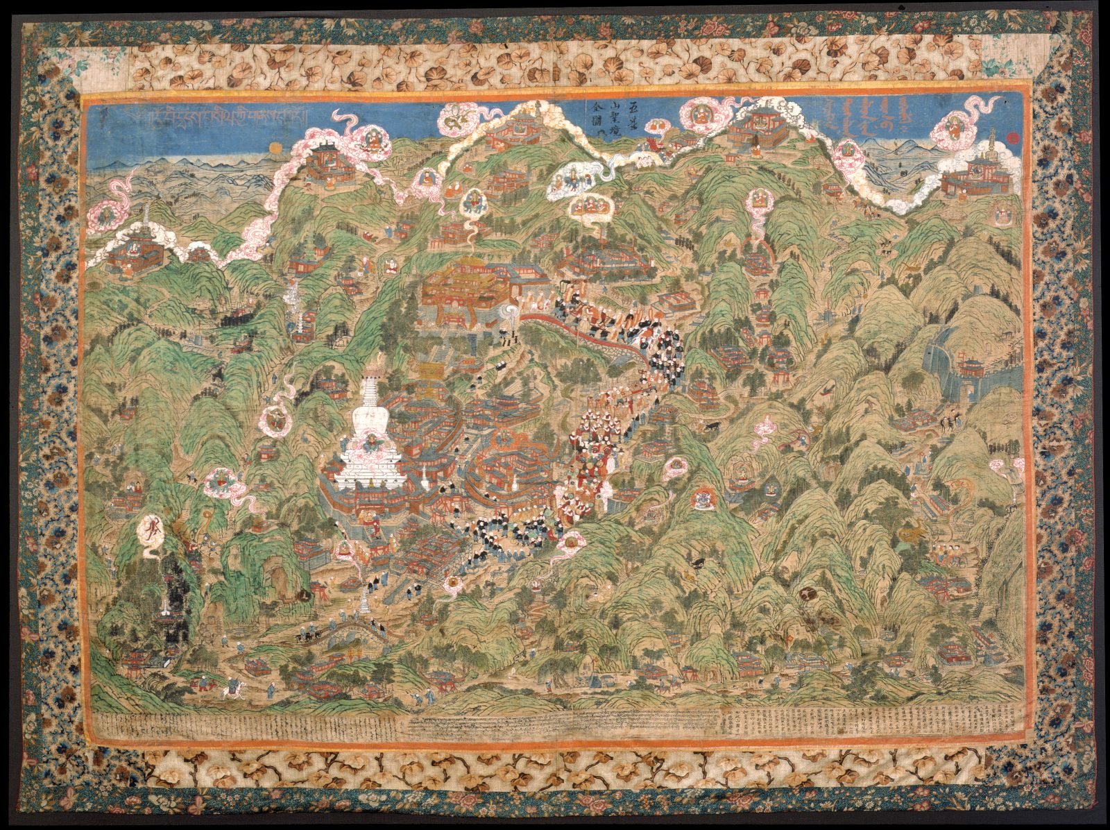
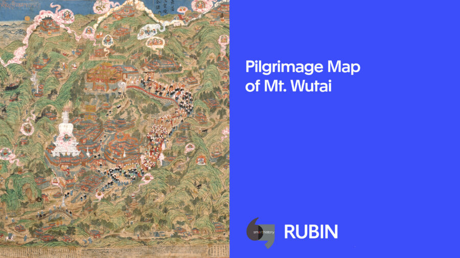
Lhundrup
Cifu Temple (慈福寺), Wutaishan, Shanxi Province, China
1846
Lhundrup
Cifu Temple (慈福寺), Wutaishan, Shanxi Province, China
1846
The sacred mountain Wutai (Wutaishan 五臺山), located in Shanxi Province, China, is believed to be the earthly abode of the bodhisattva of wisdom Manjushri. Mount Wutai was a sacred site to Chinese Buddhists as far back as the fifth century. From the seventh century on, it became an international pilgrimage center, attracting Buddhist pilgrims from as far away as India, Kashmir, Tibet, Japan, and Korea. While Tibetan Buddhism was firmly established on Mount Wutai during the Mongol Yuan dynasty (1271–1368), by the 18th and 19th centuries Mount Wutai had become especially important to Tibetans, Mongols, and Manchus.
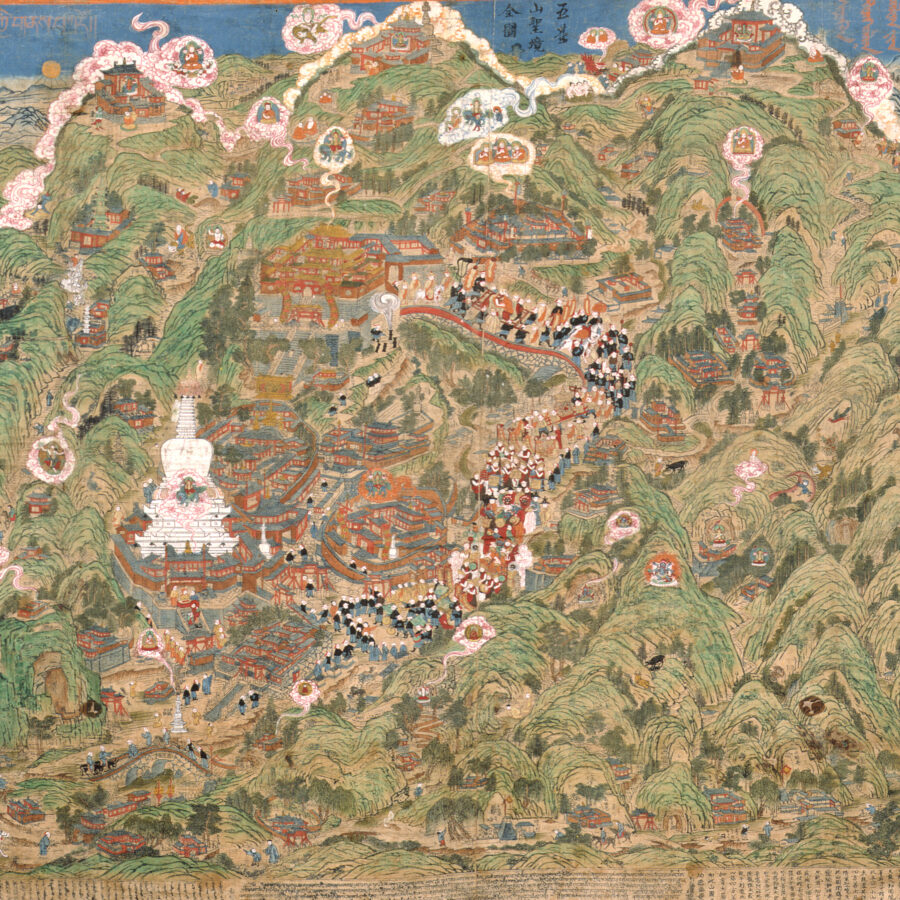
This panoramic view of Mount Wutai is an impressive, six-foot-wide woodblock print on cloth that has been hand colored. There are some 30 known surviving prints of this map. It was carved on Mount Wutai in 1846 by a Mongolian monk named Lhundrup at a local monastery, Cifu Temple (慈福寺), which served as the main lodging for Mongolian monks visiting the mountain.
This map contains more than 150 sites of interest to the pilgrims who ventured to Mount Wutai. These sites are labeled with Chinese and Tibetan inscriptions, including Buddhist monasteries, Taoist temples, villages, sacred objects, and locations of events, both historic and miraculous. Winding paths with tiny travelers link one temple to another, suggesting possible itineraries of pilgrimage. Pilgrims traveled this sacred mountain to see divine visions, which took the form of miraculous light and cloud formations, a ubiquitous presence on this map. The most prominent monastery, Bodhisattva Peak Monastery (Pusa Ding), appears much larger than the others. This temple was converted into a Manchu imperial establishment shortly after the Qing dynasty was founded in the mid-17th century, which is denoted by its bright yellow roof.
A masked dance procession, the focus of ritual activity on the mountain, leads from the monastery down the center of the map. The content of the sites and events marked on the map are a complex historical layering of Chinese, Tibetan, Mongol, and Manchu involvement on the mountain. Many Mongols were ardent followers of the Gelukpa, the monastic order of the Dalai Lama, and this map asserts not only a Tibetan Buddhist religious identity but, more specifically, a Gelukpa identity to Mount Wutai. The Gelukpa founder, Tsongkhapa (1357–1419), who was considered a Tibetan emanation of Manjushri, can be found everywhere on the map, including visions of him emanating on clouds from Mount Wutai’s five peaks. Thus, this map declares both an ethnic and sectarian identity.
The trilingual dedicatory inscriptions at the bottom promise the benefits of seeing this image, including being free from all calamities and diseases, and enjoying boundless blessings, happiness, and longevity.
Trilingual Dedicatory Inscriptions (from Debreczeny 2011:52-56)Tibetanརི་བོ་དྭངས་བསིལ་ཀི་གནས་བཀོད༎༄༅། །དུས་གསུམ་རྒྱལ་ཀུན་ཀུན་ནས་བསྔགས་པའི་ཁམས། །ཁམས་གསུམ་བར་སྣང་སྣང་བེད་འོད་འཕོས་སྐུ། །སྐུ་གསུམ་གཟུགས་སོན་སོན་པ་འཇམ་དཔལ་མཆོག །མཆོག་གསུམ་རང་ཉིད་ཉིད་དུ་གྱུར་བར་འདུད། །ཕལ་པོ་ཆེའི་མདོ་ལས། །འདི་ནས་བང་ཤར་མཚམས་གི་གནས་ཤིག་ན། །རི་བོ་དྭངས་བསིལ་ཞེས་བའི་གནས་ཡོད་དེ། །སྔོན་ཆད་རྒྱལ་སྲས་མང་པོ་དེ་ན་བཞུགས། །ད་ལྟ་རྒྱལ་སྲས་འཕགས་པ་འཇམ་དཔལ་གིས། །འཁོར་གི་བང་ཆུབ་སེམས་པ་ཁི་ཕག་བཅས།།དེ་དུ་བཞུགས་ནས་དམ་པའི་ཆོས་ཀང་གསུངས། །ཞེས་པ་དང་་་།ཡང་རིན་པོ་ཆེ་སིང་བོའི་གཟུངས་ལས། །རྒྱལ་བོ་ཀིན་ཀང་མེ་ཀི་ལ། །བཅོམ་ལྡན་འདས་ཀིས་བཀའ་སྩལ་པ། །ང་མྱ་ངན་ལས་འདས་པའི་འོག་ཏུ་འཛམ་བུ་གིང་གི་བང་ཤར་གི་མཚམས་སུ་་་རི་བོ་རེ་ལྔ་ཞེས་པའི་གནས་ཆེན་ཡོད་དེ། །འཇམ་དཔལ་གཞོན་ནུས་དེར་འགོ་འཆག་དང་འདུག་གནས་བེད་ཅིང་འགོ་བ་ཐམས་ཅད་གི་དོན་དུ་ཆོས་གསུངས་སོ། །གངས་མེད་པའི་ལྷ་ཀླུ་སེ་བརྒྱད་འཁོར་དང་བཅས་པ་རྣམས་བསེན་བཀུར་བེད་ཞེས་པ་ལ་སོགས་པའི་མདོ་རྒྱུད་དུ་མ་ནས་བསྔགས་པའི་གནས་མཆོག་འདི་ཉིད་ཀི་བཀོད་པ་མདོར་བསྡུས་ཙམ་བིས་པ། །འདི་ལ་་་མཐོང་ཐོས་དྲན་རེག་གི་འབེལ་བ་འཐོབ་ཚད་ཚེ་རབས་ཀུན་ཏུ་རེ་བཙུན་འཇམ་པའི་དབངས་ཀིས་རེས་སུ་འཛིན་པའི་རྒྱུར་དམིགས་ཏེ། །རི་བོ་རེ་་་ལྔའི་བམས་དགེ་གིང་གི་བླ་བང་དུ། །དད་ལྡན་སིན་བདག་་་་ཏཱ་ཁུ་རེའི་རེ་བཙུན་དམ་པའི་་་ཞབས་གས་་་་སངྒའི་འས་མག་གི་བརོས་པ་དགེ་སོང་ལྷུན་གྲུབ་་་ཞེས་བ་བས་རྒྱུ་ཡོན་སར་སེ་࿑ཏའི་ཆིང་ཏོའུ་ཀྭང་རྒྱལ་བོ་ཁི་བཞུགས་ལོ་ ཉེར་དྲྲུག་པའི་ས་ག་ཟླ་བའི་ཚེས་བཅོ་ལྔའི་ཉིན་པར་སྤར་དུ་བརོས་པའོ༎ ࿑ ༎སྐྱབས་མཆོག་འཇམ་དབངས་གནས་བཀོད་འདི།།གང་དང་གང་ལ་མཆོད་བས་པ། །དེ་དང་དེ་རུ་མི་མཐུན་ཕོགས། །ཞི་ནས་བདེ་སྐྱིད་དར་བར་ཤོག།༎བཀྲ་ཤིས་པར་གྱུར་ཅིག། ༎ མངྒ་ལཾ༎ro [sik ri] bo dwangs bsil kyi gnas bkod// dus gsum rgyal kun kun nas bsngags pa’i khams// khams gsum bar snang snang byed ’od ’phros sku// sku gsum gzugs ston ston pa ’jam dpal mchog/ mchog gsum rang nyid nyid du gyur bar ’dud// phal po che’imdo las// ’di nas byang shar mtshams gyi gnas shig na// ri bo dwangs bsil zhes bya’i gnas yod de// sngon chad rgyal sras mang po de na bzhugs// da lta rgyal sras ’phags pa ’jam dpal gyi// ’khor gyi byang chub sems pa khri phrag bcas// de du bzhugs nas dam pa’ichos kyang gsungs// zhes pa dang / yang rin po che snying bo’i gzungs las// rgyal bo kyin kang me kyi la// bcom ldan ’das kyis bka’ stsal pa// nga mya ngan las ’das pa’i ’og tu ’dzam bu gling gi byang shar gyi mtshams su ri bo rtse lnga zhes pa’i gnas chen yodde// ’jam dpal gzhon nus der ’gro ’chag dang ’dug gnas byed cing ’gro ba thams cad gyi don du chos gsungs so// grangs med pa’i lha klu sde brgyad ’khor dang bcas pa rnams bsnyen bkur byed zhes pa la sogs pa’i mdo rgyud du ma nas bsngags pa’i gnas mchog ’di nyid kyi bkod pa mdor bsdus tsam bris pa// ’di la mthong thos dran reg gi ’brel ba ’thob tsad tshe rabs kun tu rje btsun ’jam pa’i dbyangs kyis rjes su ’dzin pa’i rgyur dmigs te// ri bo rtse lnga’i byams dge gling gi bla brang du// dad ldan sbyin bdag tā khu re’i rje btsun dam pa’i zhabs gras sangga’i ’as mag gi brkos pa dge slong lhun grub zhes bya bas rgyu yon sbyar ste ta’i ching to’u kwang rgyal bo khri bzhugs lo nyer drug pa’i sa ga zla ba’i tshes bco lnga’i nyin par spar du brkos pa’o// //skyabs mchog ’jam dbyangs gnas bkod ’di// gang dang gang la mchod byas pa// de dang de ru mi mthun phyogs// zhi nas bde skyid dar bar shog/ //bkra shis par gyur cig/ // mangalam//.“Panoramic [Map] of Clear and Cool Mountain132Homage to this realm (Wutai shan), which all the Buddhas of the Three Times thoroughly praise; to the body radiating light that illuminates the three worlds;133 to the excellent Teacher Mañjuśrī who displays the three Buddha bodies,134 who is himself the threejewels (the Buddha, his teachings, and the monastic community).135Herein is a condensed illustrated arrangement of this supreme place of pilgrimage that many sūtra and tantra praise, such as: The Flower Garland Sūtra says:136 “In a land on the northeastern boarder from here, there is a holy site called ‘Clear and Cool Mountain.’ In former times many bodhisattvas resided there. Nowadays the bodhisattva, the noble Mañjuśrī, resides there, together with a retinue of ten thousand bodhisattvas, and preaches the holy dharma.” Also, the Ratnagarbha-dhāraṇī Sūtra says: “The Bhagavat proclaimed to Gyelwo Kyinkang Mekyi (Vajrapāṇi),137 ‘After I pass away, on the northeastern edge of the Rose Apple Continent, there is a great holy place called ‘Five-Peak Mountain’138 where the youthful Mañjuśrī roams and dwells and preaches the dharma for the sake of all beings. Innumerable [deities of the] eight classes of gods and serpent spirits (nāga), together with theirretinues, pay obeisance to him.”Intending that this [map] be a cause for all who come into contact with it via sight, hearing, and memory in all generations will be cared for by the venerable Mañjuśrī, I, the bhikṣu Lhündrup, a carver from the Sangga monastic community (ayimag) [of Amurbayas Qulangtu Monastery, Mongolia],139 the senior attendant to the faithful donor, the Jetsün Dampa of Da Khüriye (Takhuré) [Mongolia],140 applied resources to this holy map at the teacher’s residence (labrang) of Jamgé Ling Monastery141 of Five-PeakMountain, on the fifteenth day of the fourth month of the twenty-sixth year of the reign of Emperor Daoguang of the Great Qing dynasty (1846).To whom and where ever, the offering of this map of the holy land of the savior Mañjuśrī is made, there and then, may unfavorable conditions be pacified and may happiness flourish. May it be auspicious! Mangalam!”Chinese五臺山聖境全圖詩曰﹕三世諸佛稱清涼,法照三界及萬方, 文殊變化通凡聖,三寶諸仙即此身,真容久在清涼境人人敬禮無所觀。大華嚴經云,東北方有處名清涼山,從昔以來諸菩薩眾於中止住,現有菩薩名文殊師利,其眷屬諸菩薩眾一萬人,具常在其中而演說法。又寶藏陀羅尼經云,佛告金剛密跡王言,我滅度後於此南瞻部洲東北方,有國名大震那,其中有山,名曰五頂,文殊童子旅行居住,為諸眾生於中說法,及有無量天龍八部圍繞供養,斯言可審矣。此五台一小山圖,未能盡其詳細,四方善士凡朝清涼聖境,及見此山圖,聞講菩薩靈驗妙法者,今生能消一切災難疾病,亨福亨壽,福祿綿長,命終之後,生於有福之地,皆賴菩薩慈化而得也。古大窟圍智宗丹巴佛之徒桑噶阿麻格,名格隆龍住,大發愿心,親手刻造比板,以施四方善士。如有大發頭心,印此山圖者,則功德無量矣。Wutai shan Shengjing Quantu. Shiyue: sanshi zhufo cheng qingliang, fazhao sanjie ji wanfang, wenshu bianhua tong fansheng, sanbao zhuxian ji cishen, zhenrong jiuzai qingliangjing. Renren jingli wu suoguan. Da Huayanjing yun, dongbei fang you chu minQingliangshan, cong xi yi lai zhu pusa zhongyu zhongzhi zhu, xianyou pusa ming wenshu shili, qi juanshu zhu pusa zhong yi wanren, ju chang zai qizhong er yan shuofa. You baozang tuoluoni jing yun, fo gao jingang miji wang yan, wo miedu hou yu ci nan zhan buzhou dongbei fang, you guoming da zhen na, qi zhong you shan, ming yue wuding, wenshu tongzi lvxing juzhu, wei zhu zhongsheng yu zhong shuofa, ji you wuliang tianlong ba bu wei rao gong yang, si yan ke shen’ ai. Ci wutai yi xian shan tu, wei neng jinq xiangxi, si fang shang shi fan chao qingliang shengjing, ji jian ci shan tu, wen jiang pusa ling yan miaofa zhe, jin sheng neng xiao yiqie zainan jibing, hen fu hen shou, fu lu mian chang, ming zhong zhi hou, sheng yu youfu zhidi, jie lai pusa cihua ’er ’ de ye. Gu da ku wei zhizong danbafo zhi tu sanga a mage, ming ge long long zhu, da fa yuan xin, qinshou kezao ciban, yi shi sifang shangshi. Ru you dafa touxin, yin ci shantu zhe, ze gongde wuliang yi. “Panoramic Map of the Holy Realm Wutai shanAll Buddhas of the three ages praise the Clear and Cool [Mountain]. The dharma illuminates the three realms and all directions. Mañjuśrī’s transformations reach all ordinary beings and sages. The Three Treasures and all immortals are this very person[Mañjuśrī]. Mañjuśrī’s true countenance has long dwelled in the realm of the Clear and Cool Mountain, where people have paid respect to it without seeing it. The Flower Garland Sūtra (Avataṃsaka Sūtra) says, “In a place northeast of here, there is a certain region called the Cool and Clear Mountains. Many bodhisattvas from olden times have calmly abided in there. Nowadays the holy Mañjuśrī, together with a retinue of ten thousand bodhisattvas, dwells there and preaches the dharma.” In addition, the [Mañjuśrī] Ratnagarbha-dhāraṇī Sūtra says, “The Buddha said to the Vajra-wielding guardian bodhisattva ‘after I enter nirvana, in the northeastern part of the Jambudvīpa, is a country called the Great China, where there is a holy mountain called the Five Peaks, inthe midst of which the youthful Mañjuśrī roams, dwells, and preaches the dharma for the benefit of all sentient beings. At that time innumerable gods and the Eight Classes of Beings, together with their retinue, gather around to make offerings.’” You [the viewer]can investigate this for yourself. This little map of Wutai shan cannot possibly exhaust every detail of the mountain. The benefactors from all four directions who make a pilgrimage to the sacred realm of the Clear and Cool Mountain, who see this map of themountain, and who listen to and recount the spiritual efficacy and wondrous dharma of the bodhisattva, will in this life be free from all calamities and diseases, and enjoy boundless blessings, happiness, and longevity. After this life, they will be reborn in a blessed land. All these [benefits] can be acquired through the bodhisattva’s merciful transformations. Therefore, the disciple of Jetsün Dampa of Da Khüriye [Mongolia], the engraver Monk Lhündrup (Longzhu) from the Sengge Aimag, makes a great vow, to carve this woodblock with his own hands in order to extend [the merit] to the benefactors of the four directions. Should a person make the vow to print this image, they will accumulate immeasurable merit.”143(Translated by Wen-shing Chou.)MongolianTitle:ᠰᠡᠷᠢᠭᠦᠨ ᠲᠤᠩᠭᠠᠯᠠᠭ ᠠᠬᠤᠯᠠ ᠶᠢᠨ ᠣᠷᠣᠨ ᠤ ᠵᠣᠬᠢᠶᠠᠯColophon:ᠯ ᠤᠸ᠋ᠨ ᠰᠤᠸ᠋ᠠᠰᠳᠢ᠂ ᠬᠤᠷᠪᠠᠨ ᠴᠠᠭ ᠤᠨ ᠢᠯᠠᠬᠤᠭᠰᠠᠨ ᠪᠦᠬᠦᠨ ᠪᠠᠷ ᠰᠠᠢᠰᠢᠢᠠᠭᠰᠠᠨ᠂ ᠣᠷᠣᠨ ᠬᠤᠷᠪᠠᠨ ᠣᠷᠣᠨ ᠤ ᠭᠡᠭᠡᠨ ᠵᠠᠪᠰᠠᠷ ᠢ ᠭᠡᠢᠭᠦᠯᠦᠨ ᠦᠢᠯᠡᠳᠦᠭᠴᠢ ᠪᠡᠶ ᠡ ᠲᠤ᠂ ᠬᠤᠷᠪᠠᠨ ᠪᠡᠶ ᠡ ᠶᠢᠨ ᠳᠦᠷᠢ ᠶᠢ ᠦᠵᠡᠭᠦᠯᠦᠭ ᠴᠢ᠂ ᠳᠡᠭᠡᠳᠦ ᠪᠯᠯᠮ ᠠ ᠮᠠᠨᠽᠦᠰᠢᠷᠢ᠂ ᠬᠤᠷᠪᠠᠨ ᠡᠷᠳᠡᠠᠢ ᠶᠢᠨ ᠮᠥᠨ ᠴᠢᠠᠠᠷ ᠴᠢᠬᠤᠯᠤᠭᠰᠠᠨ ᠡ ᠮᠥᠷᠭᠦᠮᠦᠢ ᠣᠯᠠᠩᠬᠢ ᠨᠣᠮ ᠳ᠋ᠦᠷ ᠥᠭᠦᠯᠦᠭᠰᠡᠨ ᠠᠠᠤ᠂ ᠡᠨᠳᠡ ᠡᠴᠡ ᠤᠮᠠᠷ ᠳᠣᠷᠥᠨ ᠡ ᠣᠷᠣᠨ ᠢᠬᠡᠨ ᠲᠤᠷ ᠲᠤᠩᠬᠠᠯᠠᠭ ᠰᠡᠷᠢᠭᠦᠨ ᠠᠬᠤᠯᠠ ᠬᠡᠮᠡᠭᠳᠡᠬᠦ ᠣᠷᠣᠨ ᠪᠤᠢ ᠪᠥᠭᠡᠳ᠂ ᠤᠷᠤᠭᠰᠢᠳᠠ ᠣᠯᠠᠨ ᠪᠣᠳᠢᠰᠠᠳᠸ ᠠ ᠲᠡᠭᠦᠨ ᠳ᠋ᠦᠷ ᠣᠷᠣᠰᠢᠭᠰᠠᠨ ᠪᠤᠢ ᠡᠳᠦᠭᠡ ᠬᠤᠲᠤᠭᠲᠤ ᠮᠠᠨᠽᠦᠰᠢᠷᠢ ᠦᠬᠦᠷ ᠪᠣᠳᠢᠰᠦᠩ᠂ ᠲᠦᠮᠡᠨ ᠲᠣᠬᠠᠲᠠᠨ ᠯᠤᠬ ᠠ ᠰᠡᠯᠲᠡᠣᠷᠣᠰᠢᠵᠤ ᠣᠮ ᠣᠮᠯᠠᠵᠤ ᠪᠦᠯᠦᠭᠡ᠂ ᠪᠠᠰᠠ ᠡᠷᠳᠡᠠᠢ ᠵᠢᠷᠦᠬᠡᠨ ᠲᠣᠭᠲᠠᠬᠠᠯ ᠠᠴᠠ᠂ ᠭᠢᠨ ᠬᠠᠩ ᠮᠢ ᠭᠢ ᠬᠠᠬᠠᠨ ᠳ᠋ᠤᠷ ᠢᠯᠠᠵᠤ ᠲᠡᠭᠦᠰ ᠥᠭᠴᠢᠭᠰᠡᠨ ᠪᠠᠷ ᠵᠠᠷᠯᠢᠭ ᠪᠣᠯᠣᠷ ᠤᠨ᠂ ᠪᠢ ᠢᠷᠸ᠋ᠠᠨ ᠪᠣᠯᠣᠭᠰᠠᠨ ᠤ ᠬᠣᠢᠨ ᠡ ᠽᠠᠮᠪᠤᠲᠢᠪ ᠤᠨ ᠤᠮᠠᠷ ᠳᠣᠷᠥᠨ ᠡ ᠶᠢᠨ ᠵᠠᠪ ᠰᠠᠷ ᠲᠦᠷ ᠲᠠᠪᠤᠨ ᠦᠵᠦᠭᠦᠷ ᠲᠦ ᠠᠬᠤᠯᠠ ᠬᠡᠮᠡᠭᠰᠡᠨ ᠪᠤᠢ᠂ ᠣᠷᠣᠨ ᠲᠡᠭᠦᠨᠳᠦᠷ ᠵᠠᠯᠠᠬᠤ ᠮᠠᠨᠽᠦᠰᠢᠷᠢ ᠣᠷᠣᠰᠢᠵᠤ ᠬᠠᠮᠤᠭ ᠠᠮᠢᠲᠠᠨ ᠤ ᠲᠤᠰᠠᠳᠤᠷ ᠣᠮ ᠣᠮᠠᠯᠬᠤᠢ ᠳ᠋ᠤᠷ᠂ ᠲᠤᠬᠤ ᠯᠠᠰᠢ ᠦᠭᠡᠢ ᠲᠩᠷᠢ ᠯᠤᠤᠰ ᠠᠢᠮᠠᠨ ᠠᠢᠮᠠᠭ ᠡ ᠦᠬᠦᠷ ᠰᠡᠯᠲᠡ ᠪᠡᠷ᠂ ᠡᠷᠭᠦᠨ ᠬᠦᠨᠳᠦᠯᠡᠯ ᠢ ᠦᠢᠯᠡᠳᠬᠦ ᠲᠡᠷᠢᠭᠦ ᠲᠡᠨ ᠢ᠂ ᠣᠯᠠᠨ ᠰᠤᠳᠤᠷ ᠳ᠋ᠠᠨᠳᠠᠷ ᠡᠴᠠ ᠰᠠᠢᠰᠢᠢᠠᠭᠰᠠᠨ ᠣᠷᠣᠨ ᠡᠭᠦᠠᠤ ᠵᠣᠬᠢᠶᠠᠯ ᠢ ᠲᠣᠪᠴᠢᠯᠠᠨ ᠵᠢᠷᠤᠭᠰᠠᠨ ᠡᠭᠦᠠᠢ᠂ ᠦᠵᠡᠬᠦ ᠰᠣᠠᠣᠰᠬᠤ ᠳᠤᠷᠠᠳᠬᠤ ᠬᠦᠷᠦᠯ ᠴᠢᠬᠦᠶ ᠶᠢᠨ ᠪᠠᠷᠢᠯᠳᠤᠯᠬ ᠠ ᠶᠢ ᠣᠯᠣᠭᠰᠠᠨ᠂ ᠲᠥᠷᠥᠯ ᠲᠤᠳᠤᠮ ᠪᠦᠬᠦᠨ ᠡ ᠭᠡᠲᠦᠯᠭᠡᠭᠴᠢ ᠮᠡᠲᠦ ᠫᠠᠦ ᠡᠳ ᠡ ᠪᠠᠷᠢ ᠳᠠᠬᠠᠨ ᠪᠠᠷᠢᠬᠤ ᠶᠢᠨ ᠰᠢᠯᠲᠠᠬᠠᠨ ᠳ᠋ᠤᠷ ᠵᠣᠷᠢᠵᠤ᠂ ᠰᠦᠰᠦᠭ ᠲᠡᠭᠦᠯᠳᠡᠷ ᠥᠭᠯᠢᠭ ᠦᠨ ᠡᠵᠡᠨ ᠢ ᠶᠡᠬᠡ ᠬᠦᠷᠢᠶᠡᠨ ᠦ ᠪᠣᠭᠳᠠ ᠷᠵᠡᠪᠽᠦᠨ ᠳ᠋ᠠᠮᠪᠠ ᠶᠢᠨ ᠰᠠᠪᠢ ᠰᠡᠩᠭᠡ ᠶᠢᠨ ᠠᠢᠮᠠᠭ ᠰᠡᠢᠯᠪᠦᠷᠴᠢ ᠭᠡᠯᠦᠩ ᠯᠾᠦᠨᠽᠦᠪ ᠪᠡᠷ ᠬᠤᠲᠤᠭᠲᠤ ᠶᠢᠨ ᠠᠰᠠᠷᠠᠯᠲᠤ ᠪᠤᠶᠠᠨᠲᠤ ᠰᠦᠮᠡ ᠤᠨ ᠰᠠᠩ ᠳ᠋ᠦᠷ ᠰᠡᠢᠯᠡᠵᠤ ᠡᠷᠭᠦᠪᠡ ᠮᠠᠩᠬᠡᠯᠠᠮ ᠃Dated inscription:ᠲᠠᠢᠴᠢᠭ ᠤᠯᠤᠰ ᠤᠨ ᠲᠥᠷᠥ ᠭᠡᠷᠡᠯᠲᠦ ᠶᠢᠨ ᠬᠣᠷᠢᠨ ᠵᠢᠷᠬᠤᠲᠤᠬᠠᠷ ᠣᠨ ᠤ ᠳᠥᠷᠪᠡᠨ ᠰᠠᠷᠠᠢᠨ ᠠᠷᠪᠠᠨ ᠲᠠᠪᠤᠨ ᠤ ᠡᠷᠬᠢᠮ ᠰᠠᠢᠨ ᠡᠳᠦᠷ ᠡ᠂ Note: Mongolian script should be turned 90 degrees clockwise for publishing(Inscription attached)Note from Tanghil (Mongolian PhD candidate who typed the Mongolian and corrected transcription for us; 5-2-25 & 5-6-25): The transcription of the student’s version you sent me [C2004.29.1_RecordedMongolianInscriptions_GinaJan2020_MtWutaishan] (contains some garbled characters)ṣerigün tungγalaγ aγula-yin oron-u jokiyal(1) Om suvasti. (2) γurban čaγ-un (3) ilaγuγsan bükün ber (4) sayišiyaγsan oron (5) γurban oron-u gegen (6) ǰabsar-i geyigülün (7) üiledügči bey-e-(8) tü, γurban bey-e-yin (9) düri-yi üǰegülüg(10) či, degedü blam-a (11) Manǰuširi, γurban (12) erdeni-yin mön činar(13) čiγuluγsan-a mörgümüi (14) olangki nom-dur (15) ögülügsen anu: Ende-(16) eče umar doron-a (17) oron nigen-dür, (18) Tungγalaγ serigün (19) aγula kemegdekü oron (20) bui büged, uruγsida (21) olan bodisadu-a tegün-(22) dür orošiγsan bui (23)edüge qutuγtu (24) Manǰuširi nökör (25) bodisung, tümen (26) toγatan-luγ-a selte (27) orošiǰu nom nomlaγaǰu (28) bölöge. basa Erdeni ǰirüken (29) toγtaγal-ača, Kin Qang-(30) mi-gi qaγan-dur ilaǰu (31) tegüs nögüčigsen ber ǰarliγ (32) bolur-un: barinirvan (33)boluγsan-u qoyin-a Jambudib-(34) un umar doron-a yin ǰab (35) sar-dur, Tabun üǰügür (36) dabaγaγula kemegsen bui (37) orontegündür ǰalaγu (38) Manǰuširi orošiǰu (39) qamaγ amitan-u tusadur (40) nom nomlaqui-dur toγo (41) laši ügei tngri (42) luus naimanayimaγ-a (43) nökör selte-ber, ergün (44) kündelel-i üiledkü terigü (45) ten-i olan sudur dandar-(46) ača sayišiyaγsan oron (47) egünü ǰokiyal-i tobčilan (48) ǰiruγsan egüni üǰükü (49) sonosqu duradqu kö rül (50) čiküy-yin barilduγ-a-yi (51) oluγsan, törül tutum(52) bükün-e getülgegči metü (53) pau-ed-e bari-daγan (54) bariqu-yin šiltaγan-dur (55) ǰoriǰu, süsüg tegüldür (56) öglige-yin eǰeni-i Yeke (57) Küriyen-ü, boγda (58) Rǰebcun-damba-yin (59) šabi, Sengge-yin ayimaγ (60) seyilbürči gelüng Lhunrub (61) –berqutuγtu-yin asaraltu (62)buyantu süme-yin sang-dur (63) seyileǰü ergübe. manggalam.Dayičing ulus-un törü gereltü-yin qorin ǰurγuduγar on-u dörben sarayin arban tabun-u erkim sayin edür-e.“Composition of the Land of Cool-Clear MountainOm suvasti! I prostrate myself before the land that has been praised by all those [Buddhas] who have vanquished the three times [past, present, and future], the supreme teacher (lama), Mañjuśrī, who, with the body of one that works to illuminate the brilliantinterstices of the Triple World, reveals the form of the Threefold Body, and before the one who assembles [in himself] the essence of the Three Jewels. In the Flower Garland Sūtra (daihuayan jing) it is said that to the northeast of here there is a certain land calledClear-Cool Mountain. Formerly many bodhisattvas resided there. Now the holy Mañjuśrī, together with myriad companion bodhisattvas, abides there preaching the dharma. Also in that dhāraṇī, the Bagavant made the following edict to Jingang miji wang (金剛密跡王, Gyelbo Kyinkang Mekyi; Vajrapāṇi): “After attaining Parinirvāṇa, in the northeast interstice of the rose-apple continent there is a place known as the Five Peaks and Passes. There resides the youthful Mañjuśrī. When he preaches the dharma for the benefit of all living beings, innumerable gods and serpent spirits (nāga) of the [page 56] eight classes, together with their retinue, perform rites of offering and respect. [In this way] this place has been eulogized in numerous sūtras and tantras. The sketching of this map is intended to bring salvation by arresting one’s attachment to every sort of thing that is found as a consequence of seeing, hearing, thinking, and touching. It was engraved and offered by the monk (gelong, gelong), Lhunrub, a carver of Sangga monastic community [of Amurbayasqulangtu Monastery] and a disciple of the faithful alms-giver, the holy Jebsun Damba of Yekhe Khüriye (present day Ulaanbaatar, Mongolia). Happiness!On the supremely good day, the 15th day of the 4th month of the 26th year [in the reign] of Daoguang [1846] of the Great Qing dynasty.”144(Translated by Brian Baumann.)Inscriptions Identifying Sites in Chinese and Tibetan(numbers follow placement on C2004.29.1_Wutaishan Gallery Map_vertical, see above)1. Guzhu lin 古竹林 (Old Bamboo Grove); Foguangsi 佛光寺 (Light of the Buddha Temple) [Tibetan name རྒྱལ་བའི་འོད་ཀི་གིང་]2. Nan Tai 南台 (Southern Terrace) ལོའི་རི་ (On its peak is Pujisi 普濟寺 (Universal Salvation Temple)); Puxian ta 普賢塔(Samantabhadra Stupa)3. Yong’ansi 永安寺 (Eternal Peace Temple)4. Bailongchi 白龍池 (White Dragon Pool)5. Luohan dong 羅漢洞 (Arhat Cave); Qingliangshi 清涼石 (Clear and Cool Stone)6. Jingesi 金閣寺 ཀིན་གང་ས ི་ (Golden Pavilion Temple) [Tibetan name གསེར་གི་བ་གམ་གིང་]7. Rizhaosi 日照寺 (Sunshine Temple)8. Jindengsi 金灯寺 (Golden Lantern Temple)9. Xi Tai 西台 ནུབ་རི་ (Western Terrace)10. Mi’an 秘庵 (Secret Convent)11. Zhong Tai 中台 དབུས་རི་ (Central Terrace)12. Qingliang qiao 清涼橋 (Clear and Cool Bridge)13. Xitiandong 西天洞 རྒྱ་གར་ཕུག (Indian Cave)14. Pusading 菩薩頂 ཕུ་ས་ཏིང་ (Bodhisattva Peak) [Tibetan name བྱང་ཆུབ་སེམས་དཔའི་སོར་]15. Zhulinsi 竹林寺 ཇུ་ལེན་ས ི་ (Bamboo Grove Temple) [Tibetan name སྨྱུག་ཚལ་དགོན་]16. Santasi 三塔寺 (Three Stupa Temple) [Tibetan name མཆོད་རེན་གསུམ་པའི་གིང་]17. Guangzongsi 廣宗寺 (Temple of Ancestral Honor)18. Bei Tai 北台 བྱང་རི་ (Northern Terrace) (on it Lingyingsi 靈應寺 (Spirit Response Temple))19. Wannian bing 萬年冰 (Ice of Myriad Years)20. Heilong chi 黑龍池 (Black Dragon Pool)21. Cifusi 慈福寺 (Kindness and Happiness Temple)22. Pule yuan 普樂院 (Universal Joy Cloister)23. Liangfang yuan 兩房院(Two Houses Cloister)24. Jifusi 吉福寺(Auspicious Blessing Temple)25. Qifosi 七佛寺ཁི་ཧོ་ས ི་ (Temple of the Seven Past Buddhas) [Tibetan name སང་རྒྱས་བདུན་གི་གིང་]26. Luohantai 罗汗台(羅漢台) ལོ་ཧན་ (Terrace of the Arhats) [Tibetan name གནས་བརན་གི་ཁི་]27. Lanransi 闌然寺(Lanran Temple)28. Dong Tai 東台(Eastern Terrace) ཤར་རི་29. Lizita 笠子塔རྩ་ཞྭ་མཆོད་རེན་ (Bamboo Hat Stupa)30. Wanghai lou 望海樓(Viewing the Ocean Pavilion)31. Luoluo dong 罗罗洞(Luoluo Cave)32. Xitiansi 西天寺 (Western Heaven (“India”) Temple)33. Yongquansi 湧泉寺34. Qianfo dong 千佛洞(Thousand Buddha Cave)35. Shegousi 蛇溝寺 (Serpent Pond Temple)36. Fanxian shan 梵仙山(Indian Sage Mountain)37. Zhenhaisi 鎮海寺ཇིན་ཧའིས ི་ (Taming the Ocean Temple) [Tibetan name རྒྱ་མཚོ་འདུལ་བའི་གིང་]38. Xing gong 行宮 (Residential Palaces)39. Baiyunsi 白雲寺(White Cloud Temple)40. Tayuansi 塔院寺ཐ་ཡོན་ས ་ (Stupa Grove Temple) [Tibetan name ནོར་བུ་ཆེན་པོའི་མཆོད་རེན་གི་ལ་ཁང་]41. Luohousi 羅睺寺(Rahula Temple) [Tibetan name སྒྲ་གཅན་འཛིན་གི་ལ་ཁང་]42. Shuxiangsi 殊像寺(Manjushri Image Temple) [Tibetan name མཚར་སྡུག་སྐུ་བརྙན་གིང་]43. Guanyin dong 觀音洞གྭན་ཡིན་དུང་ (Cave of Avalokitesvara) [Tibetan name སྤྱན་རས་གཟིགས་ཀི་ཕུག]44. Nainai miao 奶奶庙(Grandmother Temple)45. Cifu miao 慈福庙(Kindness and Happiness Temple)46. Yuhuang miao 玉皇庙 (Jade Emperor Temple)47. Qixiansi 棲賢寺 (Respite of the Worthy Temple)48. Wenshu dong 文殊洞(Manjushri Cave)49. Gongbu shan 公布山 (Mahakala Hill)50. Zhaoyang dong 朝陽洞(Rising Sun Cave (Vajrapani Cave))51. Nanshansi 南山寺(Southern Mountain Temple)52. Mingyuechi 明月池 (Bright Moon Pool) [Tibetan name ཟླ་བ་གསལ་བའི་རིང་བུ་]53. Wanlü’an 萬綠庵(Myriad Green Convent)54. Heiya dong 黑崖洞 (Black Cliff Cave)55. Pu’ansi 普安寺(Universal Peace Temple)56. Shuilian dong 水連洞(Water Confluence Cave)57. Baiyundong 白雲洞པེ་ཡོན་བདུང་ (White Cloud Cave)58. Jingangku 金剛窟(Vajra Cave)59. Haihui’an 海回庵 (Return to the Ocean Convent)60. Dasi 大寺 (Great Temple)61. Heima shi 黑馬石 (Black Horse Stone)62. tAra NatA’i mchod rten ཏཱར་ནཏཱའི་མཆོད་རེན་ (Taranata Stupa) (no Chinese inscription)63. ??? (Sixth Dalai Lama living in exile in a cave) (no inscription visible)- check other printings?64. Shehu chuan 射虎川(Tiger Shot Stream)65. Xiantongsi 顯通寺(Clear Understanding Temple) [Tibetan name མངོན་པར་གསལ་བའི་ལ་ཁང་]66. Yuanzhaosi 圓照寺ཡོན་ཛོ་ས ི་ (Complete Illumination Temple) [Tibetan name ཀུན་ཏུ་ཁྱབ་པའི་ལ་ཁང་]67. Shifangtang 十方堂 ཤིས་ཝང་ཐང་ (Hall of the Ten Directions) (also called Guangrensi 廣仁寺) [Tibetan name གྲུབ་ཕོགས་ཀུན་འདུས་གིང་68. Dailuoding 黛螺頂 (Deep Blue Conch Peak དྷཱ་ལོ་ཏིང་) (also called 大螺頂) [Tibetan name ཏཱ་ལོ་ཏིང་]69. Shancaidong 善財洞 (Sudhana Cave) [Tibetan name ནོར་བཟང་ཕུག70. Tailusi 台麓寺 (Terrace Foothill Temple)71. Yuhuachi 玉花池 (Jade Flower Pool)72. Shouningsi 壽寧寺 (Temple of Longevity and Tranquility) ཤེའུ་ཉིང་སི་ [Tibetan name རག་བདེ་གིང་]73. Sanquansi三泉寺 (Three Spring Temple) [Tibetan name ཆུ་མིག་གསུམ་ [also called 三全寺]74. Tiewasi 鐵瓦寺 (Iron Tile Temple) [Tibetan name ལ་ཁང་ལྕགས་ཐོག་ཅན་75. Shizi wo 獅子窝 (Lion’s Den) [also called Manjushri Temple 文殊寺]76. Long wang miao 龍王庙 (Dragon King Temple)(lower left): Fomu dong 佛母洞 (Mother of the Buddha Cave; also known as the Womb Cave) (not labeled on C2004.29.1_Wutaishan Gallery Map)Note: perhaps more inscriptions can be recorded after this object has been scanned by Google Arts Capture this Fall
A vehicle for the preservation and transmission of knowledge. The Buddha’s teachings were originally passed down through oral transmission and storytelling, and stories of the Buddha’s past lives are considered an important source of inspiration and guidance.
A meditation technique primarily used in tantric practice that involves imagining a deity in one’s mind or imagining oneself becoming a deity and carrying out various activities. Such techniques are intended to help a practitioner transform ordinary perception and achieve enlightened qualities.
Although Tibetan Buddhism was not practiced broadly in China, the imperial centers, such as Beijing and Mount Wutai, emerged as hubs of Tibetan Buddhist cultural production. The emperors of the Mongol Yuan (1271–1368), Chinese Ming (1368–1644), and Manchu Qing (1644–1911) dynasties harnessed Tibetan Buddhist ideas to consolidate their power.
Transcultural Visions of a Buddhist MountainCifu Temple, Mount Wutai, China
People across the Himalayan regions interacted with their surroundings driven by various motivations or purposes, developing diverse architectural styles.
Himalayan art spans the artistic traditions of the diverse regions and cultural spheres of the greater Himalayan mountain range, the Tibetan Plateau, and connected areas of Inner Asia.
Get the latest news and stories from the Rubin, plus occasional information on how to support our work.